An article published in the journal PNAS, with Hèctor A. Orengo, ICAC researcher and co-director of the GIAP Research Group, as the lead author presents a machine-learning data analysis from multisensor satellites.
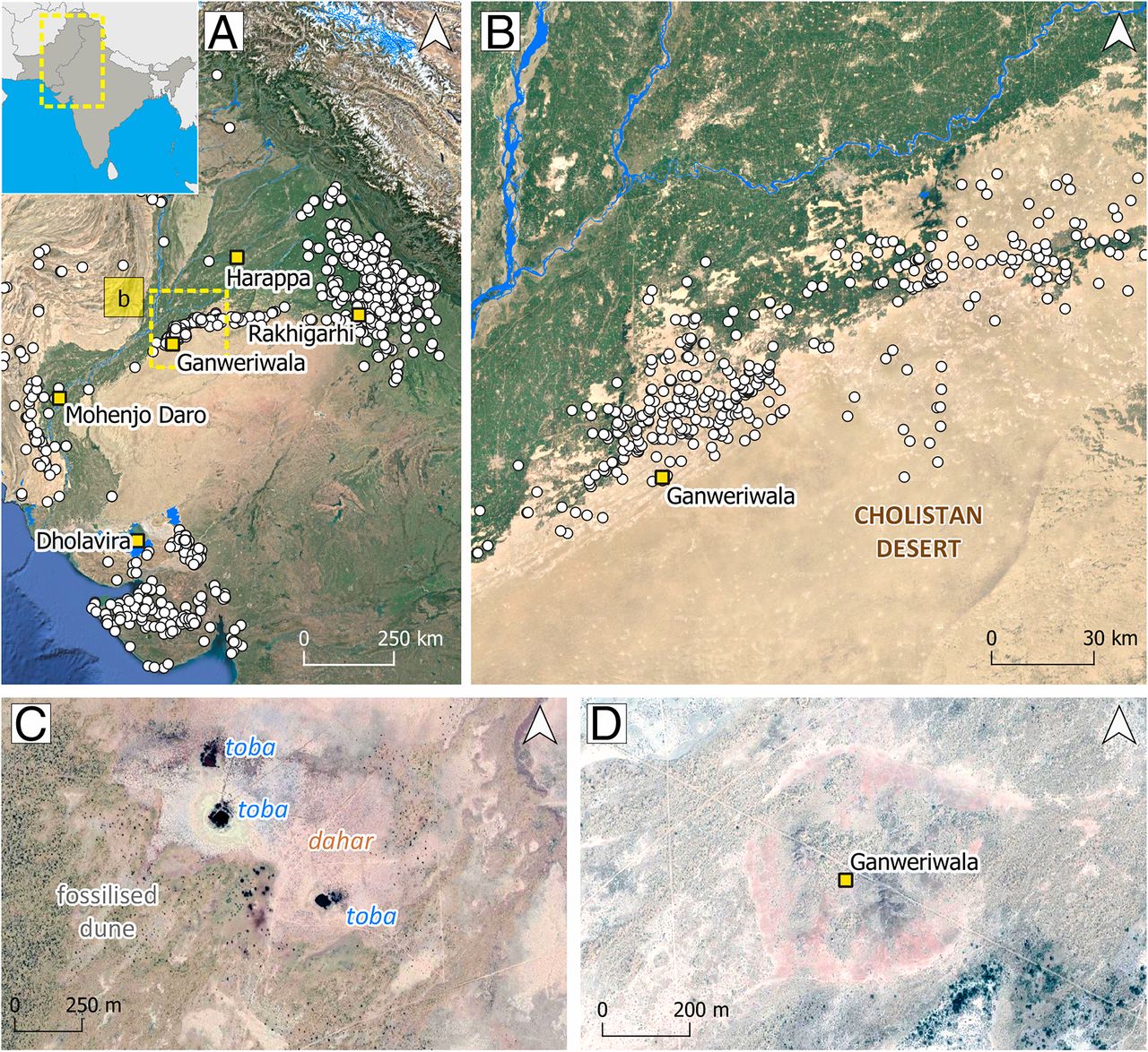
The study, which has uncovered more than a hundred new archaeological mounds in Pakistan’s Thar Desert, provides valuable information on the effects of climate change and the expansion of the desert on the Bronze Age Indus Civilisation.
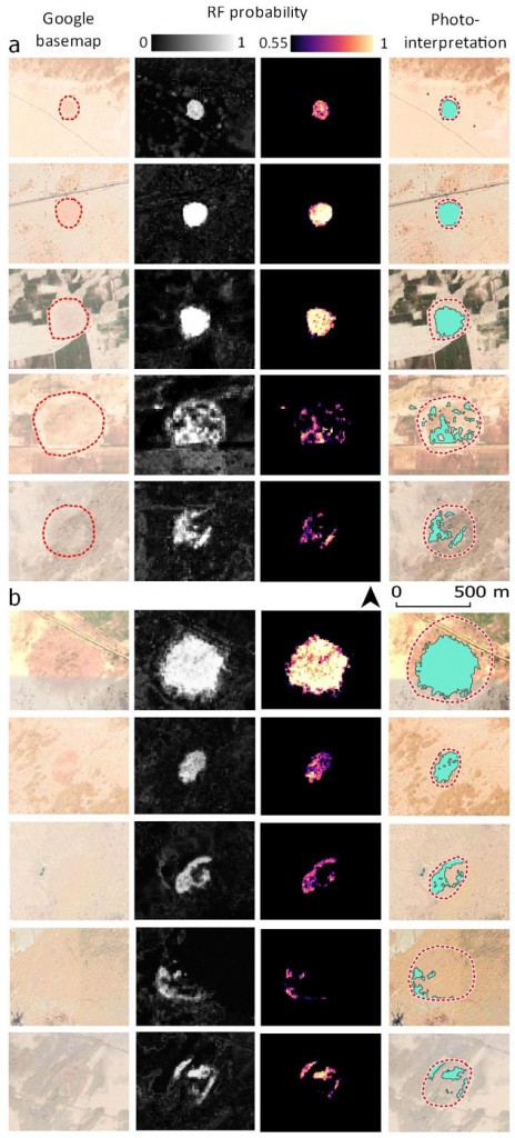
This paper presents the first application that combines the use of synthetic-aperture radar (SAR) data and multispectral imagery to detect archaeological mound sites. This is an innovative approach using multi-temporal data and makes use of imagery produced by joining 1502 SAR and 3127 multispectral images of a study area in Pakistan that were acquired during the last 6 years.
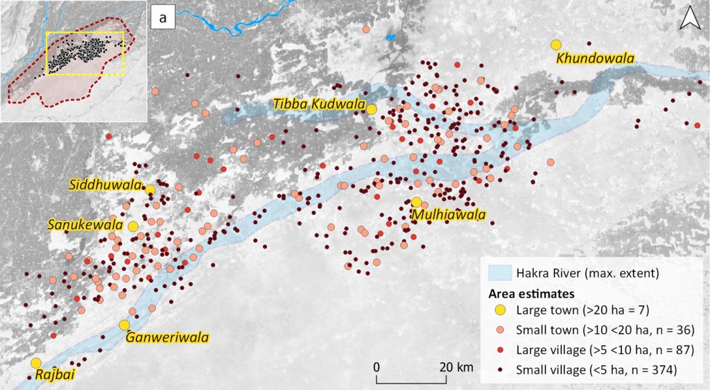
The results expand the known concentration of settlements belonging to the Indus Civilisation that are situated in the Cholistan Desert in Pakistan (c. 3300-1500 BC).
The study makes innovative use of machine learning, which is a sub-discipline of artificial intelligence. The authors used known archaeological mound locations in the desert of Cholistan in Pakistan to train a Random Forest classifier in probability mode. The classifier looked for similar signatures to those of the known sites in the combined image composite. The result was a highly accurate probability map of mound signatures in the study area that extends for over 36000 km2. The algorithm then isolated mound signatures and extracted them to create a distribution map of possible mounds in the study area.
A machine-learning algorithm to detect new archaeological sites
The results expand the known concentration of settlements belonging to the Indus Civilisation that are situated in the Cholistan Desert in Pakistan (c. 3300-1500 BC).
We have detected hundreds of new sites deeper into the desert than previously suspected, including several unexpected large-sized urban centres of around 30 ha in size, which will make an important addition to the few other large urban centres for which the Indus Civilisation is known.
Hundreds of new sites have been discovered and some of them correspond to unknown large urban settlements
These distribution patterns have major implications regarding the influence of climate change and desertification in the collapse of this major Old-World complex society. They suggest that the northern expansion of the Thar Desert created an unstable environment and forced the population northwards.
Palaeorivers, alongside which many of these settlements are found, are adapted to dune geomorphology, indicating that during the expansion of the desert the inhabitants had access to seasonal water and tried to adapt to increasingly deserted conditions. Ultimately, the desert absorbed large areas of the Cholistan and the area had to be abandoned.
We believe that the loss of the Cholistan, which was located in a central position between the different Indus Civilisation areas, was potentially an important factor in the generalised processes of de-urbanisation, decrease in settlement size and regionalisation that characterise the Late Harappan period across the Indus region.
Analysis of a desert in Pakistan, with the location of hundreds of new settlements
The authors have been able to locate hundreds of new settlements in the Cholistan Desert in Pakistan, which is an area currently difficult to visit but rich in archaeological remains, dating back at least Bronze Age.
Most of these mounds are protohistoric settlements, which stretched over a larger area than was previously recognized.
The study is contributing new insights into the population dynamics of the Indus Civilization (from 3,300 to 1,500 BC) provides valuable information for creating a map and a regional heritage database.
“The results of our study have important implications for understanding the archaeological importance of the region», the authors conclude, noting that this is the first regional approach to detecting and recording archaeological heritage through satellite imagery.
The code for the algorithm has been written in JavaScript to be implemented in Google Earth Engine, which is a geospatial analysis platform linked to Google’s cloud computing resources and provides access to several petabytes of satellite imagery covering the last 40 years.
The code is freely available to be used in any other study area and includes detailed instructions for its implementation in Google Earth Engine, which is freely accessible and only requires registration.
Full-potential results featured in a top-rated journal
PNAS (or the Proceedings of the National Academy of Sciences of the United States of America) is one of the world’s most-cited and comprehensive multidisciplinary scientific journals, publishing more than 3,300 research papers annually and with a background of over 100 years publishing multidisciplinary research.
The approaches that the authors have developed for this paper have the potential to completely transform the ways that archaeologist carry out their research. It will now be possible to detect potential sites across extremely large areas before even going into the field, and by using this knowledge archaeologists will then be able to carry out much more targeted research on the ground.
So-far results are spectacular: hundreds of new sites have been discovered and some of them correspond to unknown large urban settlements. Many of these sites have been unexpectedly located deep in the Cholistan desert.
These results open new avenues for the analysis of the impact of climate change in past populations but also for the particular role of the Cholistan in Ancient Indus dynamics and how its gradual disappearance under the desert’s sands could have influenced the fall of the Indus Civilisation.
Get full access to the paper here:
H. A. Orengo, F. C. Conesa, A. Garcia-Molsosa, A. Lobo, A. S. Green, M. Madella & C. A. Petrie (July 2020). «Automated detection of archaeological mounds using machine-learning classification of multisensor and multitemporal satellite data«. PNAS https://doi.org/10.1073/pnas.2005583117