The project Mapping Archaeological Heritage in South Asia (MAHSA) is funded by Arcadia Foundation and aims to support Pakistani and Indian Archeology and Heritage Management Professionals to identify and protect the historical and prehistoric heritage of the area, using sustainable approaches.
Hèctor A. Orengo, Ramón y Cajal researcher at the ICAC and codirector of GIAP, is the leading researcher of the project at the ICAC, coordinated by Cambridge University (with Cameron Petrie as leading researcher) and with the participation of the University Pompeu Fabra, UPF (with Marco Madella).
GIAP team, led by the researcher Hèctor A. Orengo, has made a step forward in the application of deep learning and computational archeology to remote sensing, as it is one of the partners of the project Mapping Archaeological Heritage in South Asia (MAHSA), together with University Pompeu Fabra (UPF, Spain) and under the coordination of the University of Cambridge.
“This project is a great opportunity to develop new tools for remote sensing and world heritage protection when this is most needed due to increased pressure related to the expansion of intensive human activities”, Marco Madella (UPF).
The MAHSA project aims to boost knowledge of South Asian archaeology and help local archaeologists and heritage management professionals to develop more sustainable methods. Its main objective is to protect and monitor the most vulnerable and in danger of destruction heritage through an approach based on digital humanities: remote sensing, machine learning, and the complete digitization of existing archives with conventional archaeological surveys and record-based investigations are some of the methods used.
MAHSA is a 3-year project under the coordination of Cambridge University (lead by Cameron A. Petrie, professor at the Archaeology Department in this center), and has two international partners: ICAC-GIAP and the University Pompeu Fabra (UPF). Their leading researchers are, in these institutions, Hèctor A. Orengo, Ramón y Cajal researcher and co-director of the GIAP researcher team at the ICAC; and Marco Madella, ICREA professor and researcher at the Humanities Department and coordinator of the Research Group on Culture and Soci-Ecological Dynamics (CaSEs) at the UPF.
An example of how digital humanities can be applied to urgent social needs
An excellent opportunity to develop tools for remote sensing and world heritage protection.
MAHSA project is an excellent example of how methodologies based on the digital humanities can be applied to specific and urgent social needs: “Our work, developed in South Asia, will create the first and most complete heritage catalog of this key region, which has seen the development of the first urban civilization of the Old World (the Indus civilization) and the Mughal Empire (or Timurid), one of the first states of Asia”, says Marco Madella.
Cultural heritage in South Asia, seriously threatened
Archaeological sites and monuments around the world are increasingly at risk from human activities (for example, the expansion of urban centers and industrialized agriculture) and the impact of climate change.
This is especially serious in South Asia for a number of reasons: local heritage agencies are often under-resourced; databases of existing archaeological sites and monuments are often neither digitized nor available; many of these places are not yet documented and there are large areas that remain archaeologically difficult to study due to their political instability.
In addition to the intensity of natural and human hazards, these factors combine to make the implementation of management planning, impact assessments, and long-term mitigation and monitoring measures especially difficult.
Collaboration with local entities to create a geospatial database
One of the key aspects of the MAHSA project is the knowledge transfer and training of heritage professionals to the region and to work with local agencies and specialists to develop an open access, collaborative, sustainable geospatial relational database that serves as the main cartographic resource and deposit for the protection and investigation of the local patrimony.
Collected and analyzed data will be used to develop country-specific recommendations for future research priorities, as well as management and mitigation strategies.
Cambridge University, ICAC, and UPF will collaborate with local interest groups in Pakistan and India to document endangered archeology and cultural heritage in the Indus River basin and surrounding areas: they will work with colleagues from these two Asian countries to collect and systematize existing published and unpublished data (grey literature) on archaeological and cultural heritage.
The data collected and analyzed will be used to develop country-specific recommendations for future research priorities, as well as management and mitigation strategies, in coordination with national, regional and international archaeological heritage management agencies.
MAHSA is funded with 1.8 million pounds sterling (about 2 million euros) by the Arcadia Foundation, a charity that supports the task of preserving and protecting cultural heritage and ecosystems in danger, with the will to defend the complexity of human culture and the natural world.
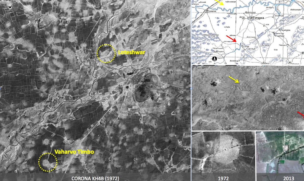
Examples of the use of cartography, satellite images and original photographs to identify and monitor the preservation heritage of archaeological sites in Gujarat (India). Two archaeological sites are identified in the images: one is Loteshwar (a hunter-gatherer and agro-pastoralist settlement dating back more than 7,000 years) and the other Vaharvo Timbo (a hunter-gatherer site of about 5,000 years ago).
Both locations were identified by applying artificial intelligence to satellite images, and their “preservation history” can be assessed using CORONA (old) and Google Earth (newer) images. The locations are clearly identifiable, but a change in Loteshwar’s preservation levels can be detected between 1972 and 2013 (bottom right of illustration). Evidence of heritage is also checked on old maps of the Soviet Union from the 1950s (top right of illustration).


