Remarkable success of our MSCAs applications for the 2021 call!
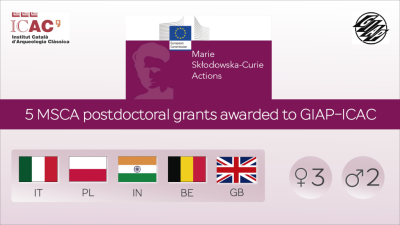
GIAP research group is been awarded five new MSCA postdoctoral grants from the European Commission, which announced the resolution of the 2021 call last Monday, March 21. A sixth proposal is also placed on the reserve list.
A recognition of the excellent work done by the GIAP! The new projects will expand research in the forthcoming years, providing research funds for a total value of almost 900,000 euros, in the following areas: archaeobotany, artificial intelligence, computational archaeology, food archaeology, geoarchaeology, and remote sensing.
Besides the obvious research opportunities these present –especially for our archaeobotany, remote-sensing, and computational research lines–, they also enrich our already-international team GIAP with new researchers from across Europe and beyond.
You can read below the general information about the proposals granted by the EC with an MSCA 2021 call postdoctoral grant.
1. IArchMap: Intelligent Archaeological Mapping of Long-Term Settlement in Punjab
- Candidate: Dr Aftab Alam (India)
- Supervisors: Dr Arnau Garcia-Molsosa and Dr Hèctor A. Orengo
Abstract:
Intelligent Archaeological Mapping of Long-Term Settlement in Punjab (IArchMap) will develop a new workflow for archaeological regional surveys through the application of machine learning methods to historical maps, multitemporal multisource satellite data and drone-acquired high-resolution imagery. These will be tested and complemented by field ground-truthing and analysis of field material. This new methodological approach will allow archaeologists to map and characterise information on past human settlement over large areas with an unprecedent speed and accuracy.
2. NetFoodIt: Networking food plant imports in Roman Italy
- Candidate: Dr. Federica Riso (Italy)
- Supervisors: Dr. Alexandra Livarda y Dr. Hèctor A. Orengo
Abstract:
The emergence of the Roman Empire marked a series of significant political and socio-economic changes across modern-day Italy as well as across a very large part of modern-day Europe. Among these, the establishment of a new transport network and the development of trade and commerce that this facilitated, was one of the most important and lasting changes.
NetFoodIt aims at using imported food plants, for the study of Roman transport and movement and the socioeconomic dynamics that this established within the core of the Roman Empire and its broader surroundings, that is, across modern-day Italy. In doing so NetFoodIt will shed new light into the relation between mobility, commerce and the introduction of new tastes in Roman Italy.
3. PlantNetGem: Exploring the process of urbanisation in the Roman provinces of Germania through the study of food plant commerce
- Candidate: Dr. Patricia Vandorpe (Belgium)
- Supervisors: Dr. Alexandra Livarda y Dr. Hèctor A. Orengo
Abstract:
The arrival of the Romans in large parts of current Europe had a major impact on society, with the creation of a new transport network and the development of cities being two of the most significant and lasting changes. However, so far, little work has been done to quantify and understand the connection between cities, how the netwrok developed and its lasting consequences.
Through the study of imported/introduced food plants into the provinces of Germania in the Roman period, PlantNetGem aims to contribute to a better understanding of foodways and the role of transport and commerce in the development of the population nuclei in this area.
4. SIGNATURE: Mapping endangered cultural soilscapes in post-conflict regions through Big Earth Observation Data, artificial intelligence and geoarchaeological signatures
- Candidate: Dr. Sayantani Neogi (UK)
- Supervisors: Dr. Francesc C. Conesa y Dr. Hèctor A. Orengo
Abstract:
SIGNATURE aims to investigate the long-term settlement and land-use dynamics that shaped the cultural soilscapes of the Levant, with a particular emphasis on revealing new archaeological sites that have been obscured by recent agricultural encroachment and abrupt land disturbances.
The study area encompasses the endangered archaeological landscapes of the Bekaa Valley in Lebanon and its adjacent fertile plains between the Litani and Orontes rivers. As an aftermath of the Lebanese Civil War and the long-lasting conflict spillovers that followed, the traditional agronomic landscapes of the Bekaa were severely transformed by agricultural autarky.
5. UnderTheSands: Ancient irrigation detection and analysis using advanced remote sensing methods
- Candidate: Dr. Nazarij Buławka (Poland)
- Supervisor: Dr. Hèctor A. Orengo
Abstract:
Ancient irrigation systems are probably the first human large-scale landscape modifications. The analysis of the ancient irrigation systems that gave rise to and sustained the first urban civilisations goes well-beyond the study of ancient irrigation to touch topics such as climate change, sustainability, population dynamics, and ancient economy, all at the core of urbanisation as a deeply human phenomenon, perhaps the most important change in the history of humanity.
For many decades ancient water management research in archaeology was mainly focused on the Near East and surrounding regions with similar hydroclimatic conditions. The political situation in that region and, as a consequence, the lack of new data nearly stopped further scientific activities.


