New research led by GIAP members develops an algorithm for the rapid mapping and almost-real-time monitoring of threats and potential site damage by agricultural expansion and encroachment.
A new research paper published in Remote Sensing presents an integrated workflow that combines Big Earth Data and spatial analysis in Google Earth Engine to provide an efficient tool for the multi-temporal detection and monitoring of heritage at risk.
The algorithm AgriExp uses the latest Sentinel-2 satellite imagery, and it employs average bands of spectral indexes to map the yearly occurrence of crops in areas that have been recently transformed into new agricultural fields. The workflow integrates the multi-temporal mapping of land cover change with the automated evaluation and assessment of the impact of agricultural encroachment within protective buffer zones.
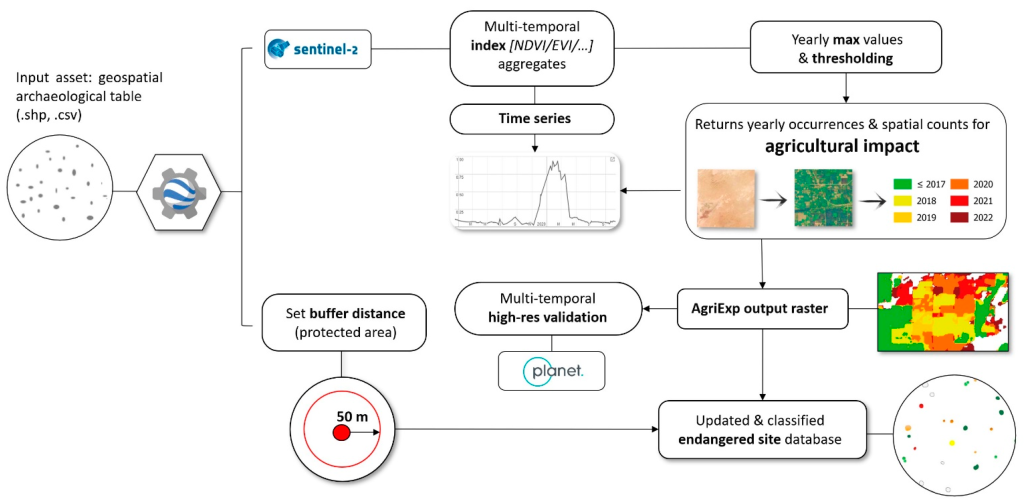
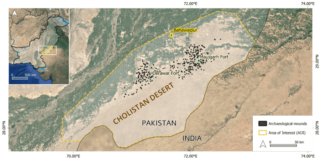
The first implementation of the algorithm has been tested in the Cholistan Desert in eastern Pakistan. “The study area is home to hundreds of archaeological mounds dating back to the Indus Civilisation. As with many other drylands elsewhere, the recent development of irrigation schemes threatens the preservation and visibility of many archaeological locations and such new developments were often largely undetected”, stated GIAP researchers Francesc Conesa and Hector À. Orengo (ICREA-ICAC).
According to this new research, the application of AgriExp has revealed a widespread land transformation of desert rangelands from 2018 onwards. In 2020 only, dozens of mounds were encroached and partially levelled, and today at least 50 % of the known mounds in the region present some degree of affectation by recent irrigation developments.
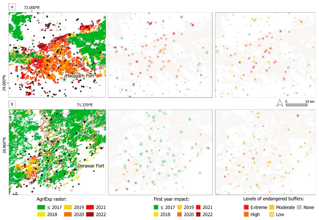
The AgriExp algorithm, recently published in Remote Sensing, represents a step forward in standardising satellite-based outputs to systematically and continuously monitor long- to short-term threats and hazards to heritage sites.
The implementation of AgriExp does not require advanced computational skills or data pre-processing. As such it has potential not only for academic use, but also for heritage agencies and practitioners, in particular for those professionals working in drylands where pedestrian or in situ monitoring of damage is not always possible and hundreds of archaeological and historical sites still remain unprotected.
Agustín Lobo, researcher at the GeoSciences Barcelona (GEO3BCN-CSIC) research center, has collaborated in the design of this method to detect agricultural fields near cultural heritage sites from time series of satellite images. The work has been led by the Research Group on Landscape Archaeolgy GIAP of the Catalan Institute of Classical Archaeology (ICAC).
News originally posted in English at GIAP webpage
¡Check out the paper in Open Access!
Conesa, F. C.; Orengo, H. A.; Lobo, A.; Petrie, C. A. (2023). “An Algorithm to Detect Endangered Cultural Heritage by Agricultural Expansion in Drylands at a Global Scale”, Remote Sensing, Vol. 15, Issue 1, https://doi.org/10.3390/rs15010053
Use these results!
The associated code, scripts and original data to run the algorithm are also available at the CORA open repository: https://doi.org/10.34810/data600
Funding and acknowledgements
Francesc C. Conesa, Beatriu de Pinós Fellow (2020-BP-00203) and Hector À. Orengo (ICREA-ICAC), conceived this research as a Juan de la Cierva-Incorporación Fellow (IJC2018-038319-I, Spanish Ministry of Science, Innovation and Universities) as a result of his Marie Sklodowska-Curie Action fellowship held at the University of Cambridge (MarginScapes, no. 794711).
Cameron A. Petrie coordinates the Arcadia Foundation-funded project MAHSA, Mapping Archaeological Heritage in South Asia (University of Cambridge) and was also the PI on the ERC-funded TwoRains project (no. 648609). Agustín Lobo is a researcher at GeoSciences Barcelona (Geo3Bcn, Spanish National Research Council CSIC).
Planet imagery was generously provided thanks to a Planet Labs Inc. Research and Education grant licensed to F.C.C. (no. 487380). We also thank the Google Geo for Good community and the Earth Engine developers’ team for their useful suggestions on the original code. We are grateful to Steve Markofsky for his comments on an earlier version of the manuscript.
El Instituto Catalán de Arqueología Clásica es un centro CERCA creado como consorcio en 2003 por la Generalidad de Catalunya y la Universidad Rovira i Virgili. Tiene su sede en Tarragona, ciudad reconocida como Patrimonio Mundial por la UNESCO en el año 2000, y está especializado en la investigación y formación avanzada en arqueología clásica.
More info: www.icac.cat/en
