The research, published in Journal of Archaeological Science, is a key advancement in the identification of qanats in the Middle East, Africa, and beyond.
Nazarij Buławka, Hector A. Orengo, and Iban Berganzo-Besga, members of the GIAP Computational Archaeology team, have created an AI model to detect qanats at the spy Cold War-era imagery. The development of the model was done in the scope of the European-funded project UnderTheSands., funded by EU (HORIZON-MSCA-2021-PF-01-101062705).

Qanats: The Ingenious Hydraulic System That Brought Water to the Desert
Qanats, karez (kārēz), are underground channels that draw water from aquifers or mountain streams. A qanat is dug with a gradual slope, ensuring the flow of clean water essential for household use and irrigation, usually connected to the canal system. Different names know this type of structure as its use spreads from large parts of the world, including South America and Japan.
As Prof. Hector A. Orengo (ICREA-BSC-ICAC) mentioned in an interview with New Scientist, “they allowed people to live in areas where it would have been unthinkable before.” Examples of qanats, known locally as galerías filtrantes or cimbras, can also be found in Spain. Interestingly, qanats are still in use today, for instance, in Morocco, where they are called khetarra (or foggara).
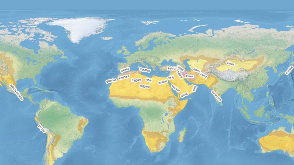
Most researchers believe this technique originated in Iran, others claim that the oldest known are form Oman. It is generally accepted that the spread of qanats is linked to the reach of the Achaemenid Empire (650–330 BCE) and later the Arab conquests (from the 7th century CE), which expanded into North Africa and the Iberian Peninsula. With the Spanish colonization, qanats also spread to the Americas. The oldest full technical description how to build qanats comes from Persian scholar Abubakr Mohammad Karaji (953 CE–1029 CE).
The use of declassified satellite images and pioneering AI reveals ancient secrets hidden beneath arid lands
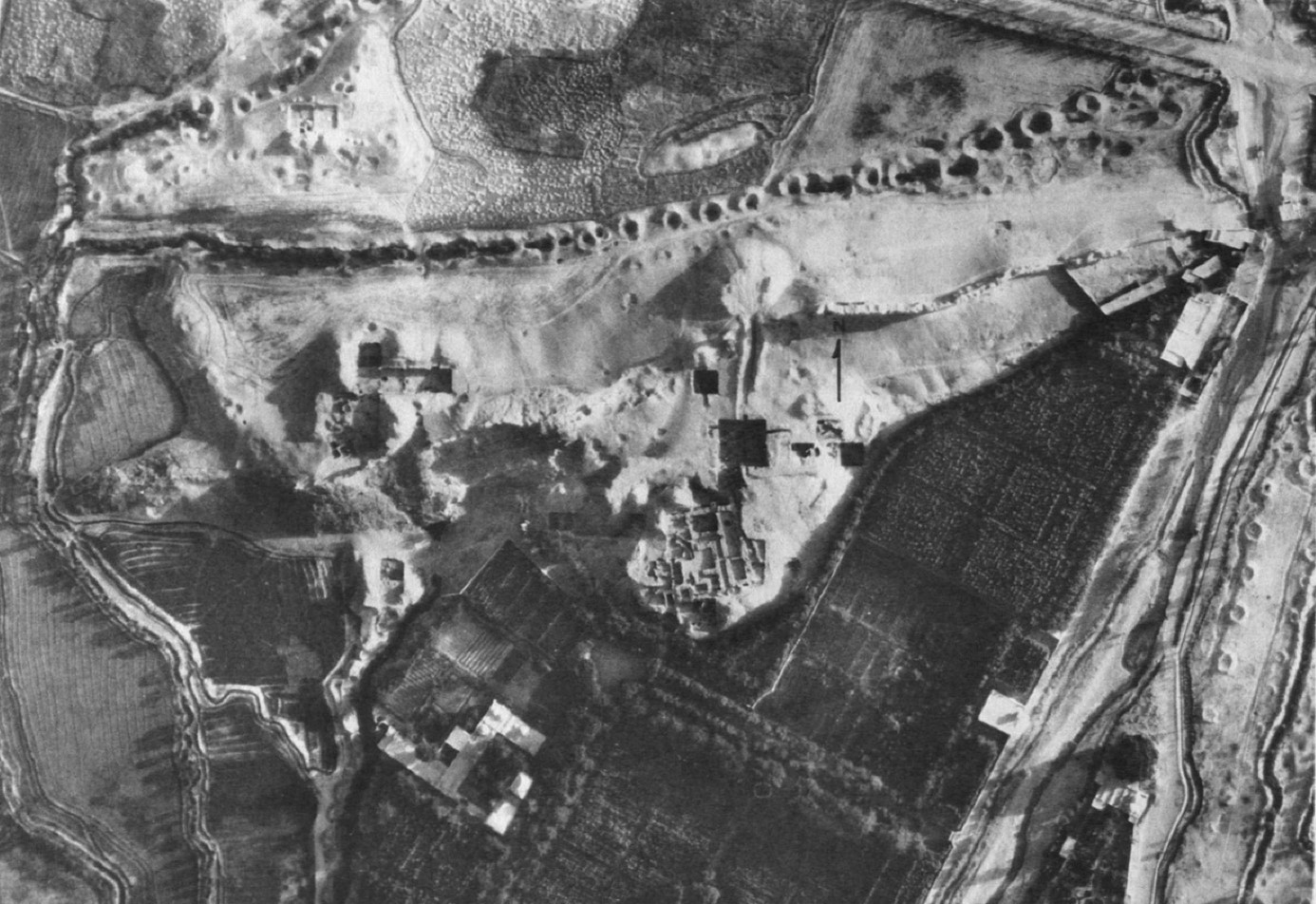
On the surface, a qanat system is a line of regularly spaced shafts (wells) used to remove debris during excavation or clean the tunnel. This feature enables qanats to be detected from space. The most significant problem usually encountered in the qanat studies is that individual shafts are preserved differently and can easily be mistaken for any other objects, wells and pits, which are very common. Moreover, many of the previously existing qanat systems have been destroyed. Therefore, aerial imagery or early satellite imagery should be used to find old qanat systems.
There were a few approaches to automatise detection of the qanats. The most important so far were the efforts of Jason Ur’s team, which used the UNET model and CORONA satellite imagery. The model, however, worked only using a specific type of image and was limited to one area. The results contain many errors.
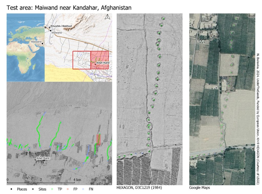
After trying out different methods, GIAP team have come up with a new solution. Instead of focusing on individual shafts, had both individual shafts and their pairs were included. Declassified HEXAGON spy satellite images and the deep learning model YOLO (You Only Look Once) were also used.
HEXAGON satellite images were taken during the Cold War to locate military targets within the Soviet Union and beyond. HEXAGON’s quality of which is comparable to the best high resolution images, but they have black-and-white colour. Since being declassified, these images have captured the attention of archaeologists, as they provide a view of landscapes before they were transformed.
As explained by Dr. Iban Berganzo-Besga (Univ. of Toronto – ICAC), YOLO is currently state-of-the-art, which is why it was chosen. The model’s effectiveness in detecting qanats lies in its high accuracy and in creating a complete workflow, from initial image processing to automatedly filtering out potential errors, explains Prof. Hector A. Orengo. The performed tests using images from Iran, Afghanistan, and Morocco proved that the model can be used to detect qanat using different images and areas.
Paving the Way for New Discoveries: Refining AI to Uncover Buried Remains
The GIAP team continues to improve the model, aiming to expand its capacity to detect qanats and other ancient irrigation systems. While the current version can detect qanats using large CORONA images and modern images converted to grayscale, future versions will include an expanded dataset and improved post-processing of the model.
By leveraging new artificial intelligence techniques, such as the Transformer deep learning architecture, researchers are opening new avenues for exploring the past with unprecedented precision. The future holds exciting advancements in detecting underground archaeological remains across various regions and eras.
About the Catalan Institute of Classical Archaeology (ICAC-CERCA)
The Catalan Institute of Classical Archaeology (ICAC-CERCA) is a CERCA center established as a consortium in 2003 by the Government of Catalonia and the Rovira i Virgili University. It is a Catalan institution with an international scope, at the forefront of research and conservation of archaeological heritage. Its headquarters are located in Tarragona, a city recognized as a UNESCO World Heritage Site in the year 2000. Its researchers work to understand the past through the study of archaeological remains and promote the preservation of the historical legacy. We are CERCA!
For more information, visit www.icac.cat.